


ARAKAN HISTORY
INTRODUCTION
Largely unknown to the Western world for much of its tur¬bulent history, Arakan played a pivotal role in the exchange of cultures and religions between India and Southeast Asia. For over a thousand years the region which now forms the Rakhine State of the Union of Myanmar (Burma) was an inde¬pendent state whose rich history is only slowly being paid the attention it deserves.
Stretching along the Bay of Bengal, from the Naaf River which separates it from Bangladesh to Cape Negrais in southern Burma, it occupies the narrow strip of land to the west of the mountains of the Arakan Yoma (Range). Land and sea routes connected it with Bengal to the west and Burma proper to the east, routes that were travelled by peo¬ples, religions and cultures. When its neighbours were weak, Arakan was able to expand its influence along the coast to the east, west and south. At other times strong and aggressive neigh¬bouring states would drive the Arakanese back to their home¬land in the north or, at times, seek to conquer them.
Arakan’s heartland was in its north, based on the rich alluvial flood plains of the adjoining Kaladan and Le-mro valleys. The earliest cities were in the Kaladan valley, backed by hills and facing west, and were thus open to influence from India and beyond. Subsequently cities were founded west of the Le-mro River, more accessible to Burma proper. The greatest city, Mrauk-U, bestrides the gap between these two valleys and thus could control both. All these cities were accessible to the Bay of Bengal through the tidal Mayu, Kaladan and Le-mro Rivers and their tributaries.
From the early centuries of the present era Arakan was ruled by kings who adopted Indian titles and traditions to suit their own environment. Indian Brahmins conducted the royal cer¬emonial, Buddhist monks spread their teachings, traders came and went and artists and architects used Indian models for in¬spiration. In the later period, there was also influence from Islamic courts of Bengal and Delhi. As an important centre for trade and as a goal of Buddhist pilgrims it was also the recipi¬ent of influence from other cultural centres in Southeast Asia. But the peoples of Arakan – like their counterparts elsewhere In the region – also followed older traditions connected with their land and the spirits which guarded it. Many of these still survive in fertility and spirit cults, or have been absorbed into the Buddhist Pantheon.
Arakan was discovered and forgotten by the rest of the world as its power rose and fell. In the first century AD the Alexandrian geographer Ptolemy knew it as Argyre, the land of silver, which was visited by merchants from southern India. Chinese Buddhist pilgrims of the seventh century knew it and the area of east Bengal within its cultural sphere as A-li-ki-lo or Harikela. The Burmese inscriptions of Pagan and Ava from the twelfth to fifteenth centuries refer to the Country as Rakhaing, the Tibetan historians Rakhan, and the Sri Lankan chronicles Rakhanga. Portuguese explorers from the fifteenth century call it Rachani and Aracan, and were followed in this by the later Dutch and English traders. The spelling ‘Arakan’ became standard in the eighteenth century.
After Arakan was annexed to India by the British in 1826 a number of scholar-administrators began to study in antiqui¬ties, and in 1889 Dr Emil Forchhammer, a Swiss Pali scholar employed by the Government of India, undertook a survey of the sites of the old cities and the major monuments. His com¬prehensive account remains the best to date. Later archaeolo¬gists found sites like Pagan in central Burma more accessible and attractive than those in remote and malarial Arakan, al¬though the region was visited briefly by Charles Duroisclle all 1920 and by U Lu Pe ‘Will in 1940, Nevertheless, the sites always attracted Arakanese scholars, especially U San Shwe Bu who worked with British colleagues in the writing, of Arakanese history. A resurgence of interest led by key Arakanese in the Burmese central government in the 1970s led to further study being undertaken by Professor of architecture U Myo Myint Sein and to the present writer’s work on the cultural history of the early period. Some Vesali sites were excavated in the 1980s by the present Director-General of the Department of Archae¬ology in Myanmar, U Nyunt Han. Recognising the tourist potential of the region, the government declared the old city of Mrauk-U a Heritage area in 1996. It is now committed to funding restoration of key shrines, and excavation of the place sites of Vesali and Mrauk-U underway.
HISTORICAL OVERVIEW
We cannot be sure who the earliest inhabitants of Arakan were. Most probably they included some minor¬ity groups still surviving in the remoter areas: the Chin, the Mro and the Sak. The dominant group today, the Rakhaing, appear to have been an advance guard of Burmans who began to cross the Arakan Yoma in the ninth century. The traditional histories of the country claim the origins of the Arakanese people in a remote past when the legendary hero-ancestor of the Arakanese, Marayu, founder of the first city, Dhanyawadi, is said to have married the daughter of a Mro chief and to have cleared the country of Bilus, demon-like creatures who may have been Chills. These histories incorporate earlier traditions and legends.
From around the 4th century other sources begin to contrib¬ute to our interpretation of the history of the country. Most important are the art and architecture which tell the story of the development of religious ideas and beliefs and help us lo¬cate the origins of these through all analysis of their style. The political history is outlined in the inscriptions of the rulers, notably those of the Shit-thaung pillar, a great stone stele in¬scribed by kings from the 6th century and carried from capital to capital until it reached Mrauk-U in the 16th. The lists of kings the inscriptions contain are verified by coins bearing their names. And we have local histories, mostly written by Bud¬dhist clergy, recounting stories of kings and shrines and draw¬ing in part from an earlier oral tradition.
Buddhist traditions are the most important in the formation of Arakan’s culture, as indeed, is the case in the rest of Burma. As with other sites in Burma and in the rest of Southeast Asia, these traditions tell of the Buddha flying to the city of Dhanyawadi, accompanied by his disciples, and converting King Candrasuriya (“Sun-and-Moon”), after which he con¬sented to have an image of himself made in commemoration of the event. This was the famous Mahamuni (“Great Sage”) image, known throughout the Buddhist world and desired by kings who sought to conquer the country in order to carry away this powerful prize. The history of this image is entwined with that of Arakan.
The tradition of the origin of the Mahamuni image can be interpreted as an allegorical account of the introduction of Buddhism to Arakan. The first evidence we have of Buddhism is in the early sculpture of the Mahamuni shrine at Dhanyawadi.
DHANYAWADI
CIRCA MID-4TH TO EARLY 6TH CENTURIES AD
Dhanyawadi (Pali Dhannavati, “grain-blessed”) was a city typical of the earliest phase of urbanization in Southeast Asia during the first centuries of the Christian era. While ele¬ments of its culture undoubtedly derived from India, it shares many characteristics with other centres in mainland Southeast Asia linked by the sea, the Pyu polities of present-day Burma, and the Mon of Dvaravati in Thailand and Oc-Eo in southern Vietnam.
Located in country with the capacity to produce three crops of paddy rice a year, Dhanyawadi had access to the hills and the products of the hill tribes such as beeswax and stick-lac, as well as to the sea via the Tharechaung, a tributary of the Kaladan River. During the early centuries of the present era maritime trade between China, India and Europe was stimulated by the interruption of the central Asian overland trade routes. India’s demand for gold, and the Roman empire’s demand for the ex¬otic products of the Orient, led traders from India and the Middle East – often Arabs – to explore alternative sources. This brought Arakan into new trading networks. Contact with In¬dia brought new ideas. Later inscriptions and local historical traditions remember ancestors who were probably local chiefs, who adopted Indian religion and statecraft to increase their power and become kings.
This process, generally referred to as “Indianization” was an extension of the spread of certain aspects of south Asian civili¬zation which had been taking place for over a millennium in India itself, diffusing eastward and southward from its centre in the northwest of the Indian subcontinent until it finally reached western Southeast Asia: what is now Burma, Thailand, Southern Vietnam, Cambodia and the western sectors of Indo¬nesia. The concept of divine kingship, which had been im¬plicit in the Indian tradition, became explicit in Southeast Asia where the rulers sought to validate their hold over different ethnic groups and to control the means of production in a context wider than the traditional village.
Professor Paul Wheatley has described the transformation of village culture to the civilization of the city-state in terms of the changes in society which this “Indianization” brought about. The maintenance of a state appropriate to kingship required the ministrations of increasing numbers of craftsmen and arti¬sans, the most skilled of whom were often accommodated within the royal compound. It required the labour of a peas¬antry who contributed the surplus produce of their fields as a tax in kind for the support of the court, and a band of armed retainers who acted as household guards, organised the peas¬antry as militia and enforced the authority of the ruler. Mate¬rial defences – walls and moats protecting the palace and the city – were constructed and the city-state, the nagara, evolved. These transformations saw the tribal chieftain replaced by a divine king, shaman by brahmin priest, tribesmen as cultiva¬tors by peasants, tribesmen as warriors by an army, and fa¬voured the development of occupational specialisation. They were reflected in the conversion of the chief’s hut into a pal¬ace, the spirit house into a temple, the object of the spirit cult into the palladium of the state, and the boundary spirits which previously had protected the village into Indianized Lokapalas presiding over the cardinal directions.
This process can clearly be traced in Arakan, which received Indian culture by land from Bengal and by sea from other parts of India. The Anandacandra inscription on the Shit-thaung stele, after listing the ancestral monarchs, says that a king called Dvan Candra, possessed of righteousness and fortune, conquered 101 kings and built a city “which laughed with heavenly beauty” sur¬rounded by walls and a moat. From the inscription we can de¬duce that Dvan Candra ruled from around 370-425AD, and that he was the founder of the Dhanyawadi of the chronicles.
Lying, west of the ridge between the Kaladan and Lc-mro riv¬ers, Dhanyawadi could be reached by small ships from the Kaladan Via the its tributary, the Tharechaung. Its city walls were made of brick, and form an irregular circle with a perimeter of about 9.6 kilometres, enclosing an area of about 4.42 square kilometres. Beyond the walls, the remains of a wide moat, now silted over and covered by paddy fields, are still visible in places. The re¬mains of brick fortifications can be seen along the hilly ridge which provided protection from the west. Within the city, a similar wall and moat enclose the palace site, which has an area of 0.26 square kilometres, and another wall surrounds the palace itself.
As was the case in the contemporary Pyu cities of central Burma, the majority of the population would have lived within the outer city, whose walls also enclosed the fields in which they worked. At times of insecurity, when the city was subject to raids from the hill tribes or attempted invasions from neigh¬bouring powers, there would have been an assured food supply enabling the population to withstand a siege. The city would have controlled the valley and the lower ridges, supporting a mixed wet-rice and taungya (slash and burn) economy, with local chiefs paying allegiance to the king.
From aerial photographs we can discern Dhanyawadi’s irri¬gation channels and storage tanks, centred at the palace site. Throughout the history of Arakan, and indeed the rest of early Southeast Asia, the king’s power stemmed from his control of irrigation and water storage systems to conserve the monsoon rains and therefore to maintain the fertility and prosperity of the land. In ceremonies conducted by Indian Brahmins the king was given the magic power to regulate the celestial and terrestrial forces in order to control the coming of the rains which would ensure the continuing prosperity of the kingdom.
The renowned Mahamuni shrine is situated on a hill north¬east of the palace site. This may have been the location of an earlier fertility cult, controlled by local chiefs and absorbed into Buddhism as Indian influence strengthened. The shrine was to become the centre of a Buddhist cult but would incorporate earlier beliefs surrounding the spirits of the earth and the pro¬tectors of the land. While the shrine was attacked, destroyed and rebuilt many times over the centuries, and its holy image finally transported to the Burmese capital of Mandalay after the conquest of Arakan in 1784, many ancient and now badly dam- Sculptures still remain. Traditionally regarded as deities protecting the central image, they are stylistically comparable to the art of the late Gupta period in India, from around the fifth and sixth centuries AD. There are indications that the dei¬ties they represent belong to the Mahayana Buddhist pantheon.
VESALI
- CIRCA 6TH TO 8TH CELNI LRIES AD
Some nine kilometres south of Dhanyawadi is the next im¬portant city, Vesali (Wethali), founded around the begin¬ning of the sixth century and named after the Indian city of Vaisali, famous in Buddhist tradition. We do not know pre¬cisely when the centre of power moved to Vesali, but inscrip¬tions and sculptures found in the vicinity of the city can be dated from around the sixth century. Vesali is flanked by the Rann-chaung, a tributary of the Kaladan, to the west, and the ridge between the Kaladan and Le-mro Rivers to the east. As at Dhanyawadi we find an oval-shaped city wall encompassing an area of seven square kilometres, protected by a moat which still fills with water in the wet season. In its centre the palace site, also surrounded by a moat, contains a royal lake. More easily reached by the overland route from India, it also took advantage (if increased trade in the Bay of Bengal at the time and its influence spread to southeast Bengal. Its material re mains show that it was in contact not only with the Pyu of central Burma but also the pre-Angkorian cultures further east. As was the case at Dhanyawadi, there was a large temple com¬plex to the northeast of the palace. Excavations in the 1980s unearthed the remains of a Buddhist monastic complex and a royal shrine containing the stone image of a bull. This was the royal insignia of the Candra dynasties which ruled at both Dhanyawadi and Vesali and who claimed to belong to the lin¬eage of the Hindu god Siva, although they themselves pro¬fessed Buddhism, probably of the Mahayanist persuasion. Such religious synthesis was not unusual in Southeast Asia, where Brahmins of Indian origin have traditionally conducted the royal ceremonial which Buddhism, disdaining class hierarchy, did not aspire to, even in Buddhist courts.
Our knowledge of the history of this period is based not only on the archaeological remains, but also on inscriptions, impor¬tantly those on the pillar now preserved at the Shit-thaung tem¬ple at Mrauk-U. The Shit-thaung pillar inscription of Anandracandra, who ruled Vesali in the 8th century, records a genealogy of some 22 kings ruling from the late 4th century, the earlier kings probably at Dhanyawadi. Anandacandra is described as a Buddhist who established monasteries, caused images to be made, and welcomed monks from other lands including the Buddhist clergy of Sri Lanka, to whom he sent an elephant and robes. He did not neglect other religions, repairing “deva” shrines, probably Hindu in character which were erected by former kings, and establishing buildings for the local Brahmins, whom he also provided with land, servants and musicians. Amongst the sculptural remains from Vesali there are stone and bronze votive stupus which give us an idea of the architec¬ture of the time, Buddha images showing contact with the Pvu of central Burma and the monastic establishments of Bengal, and a remarkable series of Visnu images, indicating the impor¬tance of that sect.
Although the extent of the lands controlled by the Dhanvawadi, Vesali, Le-mro and Mrauk-U kings would have changed under differing political and economic circumstances, the spread of historical remains indicates that from around the 6th century most of the Kaladan and Le-mro valleys came within their influence. So, for example, the discovery of a Vesali period Hindu shrine within the walls of Mrauk-U, for instance, gives an indication of the extent of the lands controlled by that city. Contact with the Pyu of central Burma is evidenced by a Pall inscription found in Mrauk-U, and another in Pyu script from Thandwe (Sandoway).
From the middle of the 8th century east Bengal, Arakan and the Pyu cities of central Burma were disrupted by waves of incursions of Tibeto-Burman-speaking peoples. These were the Mranma (in modern Burmese, Myanmar) who were eventu¬ally to make Pagan their capital, and the people who were to rule Arakan and call themselves Rakhuin (Rakhaing).
In the 9th or 10th century the administrative centre may have moved to the Mrauk-U area. The chronicles record the building of two new cities on the Mrauk-U plain, the last over¬run by invaders from the west. Some recent discoveries dating from this period show that close links with Eastern India had been maintained.
CITIES OF THE LE-MRO VALLEY
- 11TH-15TH CENTURIES
With the rise of the Burmese capital at Pagan a series of small Arakanese cities, Sambawak, Parein, Hkrit, and Launggret, succeeded each other on the lowlands west of the Le-mro River, while Toungoo Neyinzara was on its eastern side. This location gave these cities more access to Burma than their predecessors had. Smaller than their predecessors, almost noth¬ing remains of their walls and palaces.
The first capital, Sambawak was believed to have been founded by a descendant of the Candra kings of Vesali in 1018 AD. The power of Pagan was reaching its zenith at the time, and though access was difficult across the Arakan Yoma, Pagan kings often attempted to raid Arakan and to carry away its palladium, the Mahamuni image. Instead of being a country whose influence was felt in Bengal, Arakan became a tributary of Pagan and her power curtailed. Her cities were small and her hold on more remote territories weak. According to the chronicles, a usurper ultimately ascended- the throne and the royal family had to take refuge at the Burmese king Kyanzittha’s court at Pagan. When the rightful line was restored with the assistance of the Burmese, King Letya-min-nan moved the capi¬tal to Parein in 1 118 AD. Launggret was founded in 1237 AD, at a time when Pagan’s power was beginning to wane, and after a few years managed to become independent and began to again expand its authority to Bengal to the west and Cape Negrais to the south. The art of this period is strongly influenced by that of Pagan and reflects increasing religious contact with Sri Lanka, then the centre of Theravadin Buddhism.
In 1404 AD Burmese forces occupied Launggret and drove out the king, Min Saw Mun, who fled to.the Sultanate of Gaur in Bengal. Islam had been taking hold in Bengal from the 13th century, and the Bengal Sultanate, independent of Delhi, was founded in the mid-14th century. It was natural that Arakan, threatened from the west, should turn to its eastern neighbour with which it had centuries of contact. Weak but strategically desirable, it became a pawn in the struggle for power between the Burmans, now with their capital at Ava, and the Mons of lower Burma, with their capital at Pegu.
It is said that Min Saw Mun returned to Arakan with the assistance of an armed levy from the Sultan of Gaur. Following the advice of his astrologers he left the ill-omened Launggret and founded the last of the old great capitals, Mrauk-U, in 1433.
MRAUK-U 1433-1785 AD
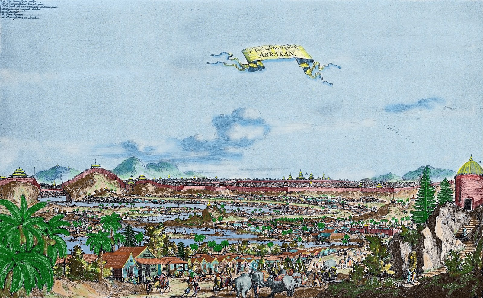
The Portuguese Jesuit, Father A. Farrinha, SJ, who trav¬elled to Mrauk-U in 1639, wrote Mrauk-U, called Arakan by the many foreigners who visited it, occupies a unique site. Situated in low land within a series of parallel ranges it commands both the Kaladan and Le-mro valleys and has access to the two main rivers, and therefore the Bay of Bengal, by both land and water.
After Min Saw Mun’s return, the country remained tributary to the Bengal Sultanate for a hundred years. The kings, though Buddhists, used Mohammedan titles in addition to their own names, some issuing coins bearing the kalima, the Muslim dec¬laration of faith, in Persian script. Min Saw Mun’s brother, All Khan, managed to occupy the Bengali coastal town of Ramu and his son Ba Saw Pru, also known as Kalimah Shah, is said to have occupied Chittagong.
The twelfth king of the line, Min Bin, who ruled from 1531 to 1553 saw Arakan reach the height of its power. Two factors assisted him in this: the arrival of the Portuguese and civil war in Bengal.
In the sixteenth century the Portuguese were the world’s fin¬est mariners. They arrived in the Bay of Bengal seeking to con¬vert the heathen to Catholicism, and in doing so to promote trading opportunities. The Arakanese saw that by granting ter¬ritorial concessions and trade openings, they could benefit through the Portuguese mastery of seamanship and their mod¬ern knowledge of arms and fortification. Min Bin thus turned Mrauk-U into the strongest fortified city of the Bay of Bengal, employing Portuguese to lay out his walls and moats and to forge and mount his cannon. He appointed them as military officers to train and equip a mercenary army of many races, and built, with their aid, a large fleet manned with his own men. It was during his reign that the Mrauk-U architectural style, draw¬ing on Burmese, Mon and Bengali prototypes, developed. The Rakhaing navy became the scourge of the Bay of Ben¬gal, taking slaves from up and down the coast as well as trad¬ing rice for luxury products for its aristocracy. The Portuguese recorded that the navy comprised three hundred and fifty ves¬sels. Ships coming from the Bay of Bengal usually approached via the Mayu River. There was a customs checkpoint at Kwede, at the beginning of the river of that name which joins the Mayu with the Kaladan. Upriver were trading posts for the produce of the region, cotton goods and rice.
That Mrauk-U controlled the economy of the Kaladan and Lc-mro valleys and their hinterlands can be seen not only in the widely scattered remains of religious buildings and Bud¬dha images of the period but also in signs of occupancy of other centres essential for trade and the defence of the city. In 1630 the Portuguese traveller Sebastian Manrique found a massive image of the Buddha at the head of a pass guarding the land route to Bengal. Punnakvun, on the left bank of the Kaladan River, was strategically placed to control access by water to Mrauk-U, and was the site of its naval base. The Urittaung pagoda stands on a low, but steep and rocky hill opposite Punnyakyun. To the west of the pagoda are two large and several smaller tanks. The ground here is strewn with earth¬enware shards indicating a long period of settlement.
Meanwhile, in Bengal, the Mughals had arrived. The emperor Humayan conquered the Sultanate of Gaur, thus initiating a long period of civil war. Min Bin took advantage of this opportunity and occupied east Bengal with a combined fleet and army movement. The province remained a vassal of Arakan for the next one hundred and twenty years, till 1666. Its administra¬tion was left in the hands of twelve local rajas, who paid an annual tribute to the Arakanese king’s viceroy at Chittagong.
From the west, Min Bin was threatened by the powerful Bur¬mese king ‘Tabinshweti, who had already conquered the Mon country and was making war against the Thais at Ayuthia. Tabinshweti invaded Arakan in 1546-7 with the help of his Portuguese mercenaries and Mon levies. When the Burmese penetrated the eastern defences of the city, Min Bin opened the sluices of his great reservoirs and halted their advance. The Arakanese chronicles tell us that the Burmese, unable to make headway, accepted the intercession of the Buddhist monks. The opposing leaders met, had amicable discussions and the Bur¬mese returned home.
The Portuguese Jesuit Sebastian Manrique, describing a simi¬lar procession before the coronation of King Sanda-thu¬dhamma wrote The Nobles and the other men of rank gather at the palace whence, amongst music of all kinds, a huge elephant emerged, richly caparisoned, with his ivory tusks adorned with rings of gold and jewels. He carried on his back a howdah made of silver. It was open on all four sides except for curtains of green and gold silver veiling. Inside it was a tray of gold set with precious stones of immense value, which bore the royal order containing the proclamation of the coronation. Just in front, before the howdah, sat the Chique, or chief-justice at the Court, clothed in white silver cloth covered with plaques of gold. In front of him was the elephant-driver or cornaca in his usual place. He was dressed in red damask and carried in his hand the accustomed implement with which that land vessel is guided, in his instance of the finest gold. He was followed in due order by thirty-two war elephants, dressed in silken cloths and ornamented with gold, bearing the usual uncovered howdahs on their backs, made of wood but covered with silver plates. They carried huge silver bells around their necks and had rings of this same metal on their tusks. Each elephant had four silken banners of various colours fastened to the howdah which trembled in the light breeze and acted as flapping fans for their heated bodies.
When, in the east, the Mughal Emperor Akbar consolidated his hold on central and western Bengal, Min Bin’s successor Raza-gri protected his eastern frontier with the aid of a menac¬ing group of Portuguese slavers and adventurers settled near Chittagong, to whom he gave trade concessions.
In 1595 the Arakanese besieged and conquered the Mon capital of Pegu, deporting 3,000 households, and taking back a white elephant and a daughter of the fallen king, bronze cannon and the thirty bronze images which the Burmese king Bayin-naung had earlier seized when he conquered Ayuthia. They left in charge Felipe de Britoy Nicote, one of their Portuguese merce-naries. For a short period Arakan extended from Dacca to Moulmein, a narrow coastal strip some thousand miles long.
But the causes of Arakan’s greatness were also the causes of its downfall. The thousands of Mughal, Burmese, Mon, Siamese and Portuguese mercenaries and prisoners of war did not bear a strong allegiance to the king. With mercenary support a pre¬tender, Narapati, came to the throne in 1638, and Arakan’s power began to decline. The influence of the Portuguese also waned as the Dutch gained commercial advantage in the Bay of Bengal. King Sanda-thudamma temporarily restored the country’s glory by allowing the Dutch to settle at Mrauk-U. Wanting to strike at Catholicism in Ceylon, the European new¬comers facilitated the sending of Arakanese monks there to revive the Buddhist ordination rites which had been in decline under the Portuguese.
Father Sebastian Manrique recorded that ……the city of Arracan according to general opinion must have contained one hundred and sixty thousand Inhabitants, excluding foreign merchants, of whom there was a great influx owing to the large number of-ship trading with this port from Bengala, Musulipattam,Tenasserim, Martaban,Achem and Jacatara. There were some other foreigners, too, some being merchants and some soldiers, the latter being enlisted oil salaries, and were, as 1 have said, Portuguese, Pegus, Burmese and Mogors .Besides these there were many Christians of Japanese, Bengal and other nationalities.
Meanwhile, in India, Shah Shuja, the Mughal pretender who had been provincial viceroy in Bengal, was defeated by his brother Aurangzeb who became Emperor at Delhi. Shah Shuja sought refuge at the Arakanese court, where King Sanda¬thudhamma is said to have lusted not only after his immense treasure but also his daughter. Shuja in desperation attempted to overthrow the city, but was defeated and executed along with his family. In retaliation the Mughals broke the power of the Arakanese in east Bengal, enslaving many who had been slav-ers and inducing the Portuguese to change their allegiance.
Many of Shuja’s Indian followers are said to have remained in Arakan, where they were employed as archers of the guard and proceeded to murder and set up kings at will. Mrauk-U’s decline continued for a century. The country was beset with civil war and by a series of natural disasters such as awesome earthquakes, although the Arakanese continued to raid the Bengal coast as late as the middle of the eighteenth century. As soon as the kings of Burma regained their power under the Alaungpaya dynasty, the Peguan territories were lost and Arakan’s southern borders were withdrawn to Cape Negrais.
After Sanda-thudhamma Arakan survived as a polity only because it had no aggressive neighbour. The Moghuls had ceased to be an expanding power, and Burma was becoming preoccu¬pied with the British. The power of the last of the many kings of this period could extend only a few miles beyond the walls of Mrauk-U. It came to an end in 1784 when the Burmese king Bodawpaya invaded and removed the protector of the country, the Mahamuni image, to his capital at Amarapura. Two hundred thousand Arakanese are said to have fled to In¬dia. These events laid the seeds for the first Anglo-Burmese war, fought in Arakan in 1825. The conquerors found the old city of Mrauk-U pestilential to its troops, and removed them to a small fishing village at the mouth of the Kaladan River, which today remains the capital of Rakhaing State of Sittwe.
Source.. http://www.narinjara.com/main/index.php/arakan-history/


2 comments:
Thank you for this comprehensive study. (Ratana sifu)
Thank you so much.
Post a Comment